 In
1609 the English explorer Henry Hudson, sailing the vessel, the Half Moon
(Figure 1), for the Dutch East India Company, manned with a mixed Dutch
and English crew, entered New York Harbor and sailed almost as far north
as present day Albany (Van Zandt 1992). His log, and the log of his crewman
Robert Juet, chronicle the earliest documented European exploration of
the river. Other early European visitors documented their initial encounters
with the Hudson River landscape and its inhabitants in a variety of ways
- logs from upriver voyages, maps, military plans and drawings. These reflect
certain types of specialized knowledge. As part of ongoing research for
our study, we hope to learn more about how the Dutch colonists, and others,
such as 18th century military cartographers, viewed the Hudson River terrain.
At present, however, we are focusing upon the physical engineering of the
river during the 19th and early 20th centuries, and upon the imaginative
construction of that same terrain - processes which we see as integral
to understanding the Hudson River landscape as we know it today.
In
1609 the English explorer Henry Hudson, sailing the vessel, the Half Moon
(Figure 1), for the Dutch East India Company, manned with a mixed Dutch
and English crew, entered New York Harbor and sailed almost as far north
as present day Albany (Van Zandt 1992). His log, and the log of his crewman
Robert Juet, chronicle the earliest documented European exploration of
the river. Other early European visitors documented their initial encounters
with the Hudson River landscape and its inhabitants in a variety of ways
- logs from upriver voyages, maps, military plans and drawings. These reflect
certain types of specialized knowledge. As part of ongoing research for
our study, we hope to learn more about how the Dutch colonists, and others,
such as 18th century military cartographers, viewed the Hudson River terrain.
At present, however, we are focusing upon the physical engineering of the
river during the 19th and early 20th centuries, and upon the imaginative
construction of that same terrain - processes which we see as integral
to understanding the Hudson River landscape as we know it today.
Early European accounts extolled the splendor of the river's scenery.
A visitor in 1638 noted that "If you would know the beauty of New England,
then you must glance your eye upon Hudson's river, a place exceeding all
yet named" (Wilmerding 1984:4). Today, the Hudson continues to be considered
a place of great natural beauty (Figure 2). Travellers on the river may still behold verdant banks and abundant wildlife.
This however obscures the fact that the riverine landscape has, in many
locations, undergone extensive changes since the early 19th century.
Travellers on the river may still behold verdant banks and abundant wildlife.
This however obscures the fact that the riverine landscape has, in many
locations, undergone extensive changes since the early 19th century.
These changes have been traced by examination of 18th, 19th, and 20th century maps and other documentary sources. Indicators of change also remain wholly or partially intact within the landscape itself, and it is in fact the observation of these material culture remains which pointed the way toward this study, which considers both artifacts in the landscape and the landscape as artifact.
Like any artifact, a landscape is dependent upon its context for
its meaning (Hodder 1991: 123). Thus changes in the Hudson River's landscape
can be understood only in relationship to the changing socio-economic environment.
These changes have also affected the nature of the Hudson as a cultural
symbol, as reflected in the iconography of the river. This iconography
includes maps, written texts such as travelers accounts and engineering
reports, and especially paintings of the artists belonging to what is known
as the Hudson River School. In examining such representations, we are attempting
to study the river as it has been imagined, as well as a material product
shaped by human activity (Watts 1992).

The New York District Corps of Engineers habitat restoration project
which served as the genesis of this study will eventually include fourteen
locations (Figure 3) on the Hudson River between New York and Albany. While
research to date has focused on four locations, the discussion presented
in this paper is based largely on the analysis of two of these - Schodack/Houghtaling
Island, extending from Castleton to New Baltimore; and Hudson South Bay
adjoining the City of Hudson.
In the course of our research we have noted major modifications in the river's morphology resulting from navigation improvement projects, railroad construction, and the making of land to support industrial production. Occurring during the early nineteenth century through the first part of the twentieth century, these three processes derived from the need to create a transportation corridor for shipping and rail traffic which would enable rapid, reliable and predictable delivery of raw materials to, and finished products from new industrial facilities which were being created both along the river and elsewhere.
1. Navigation Improvment Project
The most dramatic changes in the Hudson River's physical landscape occurred in the forty mile portion between the cities of Hudson and Waterford, just north of Troy, where the Erie Canal made its entry. The opening of the Canal in 1825 created the need to upgrade the Hudson as a transportion corridor. Without navigation improvements in this portion of the river, the Canal would have remained inacessible to steam traffic.
While the River had always been easily navigable from New York City to Hudson, above this point it was a navigational nightmare of shifting shoals, mud flats, sandbars and islets. Some of these features are shown on maps dating as early as the late 17th century (Figure 4) and the 18th century (Figure 5) century survey likened these reaches to "the sinuous curves of a serpent" (Hughes 1844:4). Elsewhere it was noted that the shoals in this portion of the river were a "severe interuption to the navigation between New York and Albany, which might otherwise be carried on in vessels of larger burthen than are now employed in this trade" (Maude 1800, cited in Van Zandt 1971:135).


Dike construction (Figure 7) was extended south to the New Baltimore area later in the 19th century and continued into the early 20th century (Figure 8).


Remains of many of these timber, stone, and concrete diking structures
(Figures 9 and 10), are still present along the river and
island shores (Figure11 and 12).


Clinton's navigation improvement plan involved the construction of parallel
rows of dikes to narrow and straighten the river channel, and dredging
of the channel between these dikes. The river current would thus be utilized
to maintain the dredged channel. The dikes would also serve to prevent
the siltation of the channel by soil eroded from island and shoreline banks.
In  addition
to the construction of parallel dikes, others served to close off side
channels (Figure 13) in order to strengthen the force of the current in
the main channel. Efforts were also made to make the bends in the river
more gradual in order to prevent the formation of bars at these locations.
The dikes themselves, as recorded in late 19th and early 20th century
photographs, such as these, made a significant visual impact on the riverine
landscape (Figures 14 and 15), especially at low tide (Hughes 1866; Newton
1872; Talcott 1867-8; Corps of Engineers 1897).
addition
to the construction of parallel dikes, others served to close off side
channels (Figure 13) in order to strengthen the force of the current in
the main channel. Efforts were also made to make the bends in the river
more gradual in order to prevent the formation of bars at these locations.
The dikes themselves, as recorded in late 19th and early 20th century
photographs, such as these, made a significant visual impact on the riverine
landscape (Figures 14 and 15), especially at low tide (Hughes 1866; Newton
1872; Talcott 1867-8; Corps of Engineers 1897).


Maps made in the latter portion of the nineteenth century and early portion of the twentieth century show the dikes, and indicate that at some locations siltation behind them had begun to transform the morphology of the river islands and the banks themselves. This process appears to have been accelerated by advances in mechanical technology (Figure 16) that made feasible the removal of greater volumes of dredged material (Figure 17) which was dumped along the shorelines and on the surface of the islands.


a. Schodack - Houghtaling Island Impacts
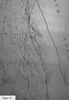
The technical requirements of the navigation improvement project created a need for more detailed maps, showing water depths and bathymetric contours. The earliest of these was drawn in 1820 (Figure 18). This section of the map depicts the grouping of islands near Coeymans which would eventually merge to become Schodack Houghtaling Island. By the time this 1867 map (Figure 19) was completed, the federal navigation project had reached the area and a number of dikes had been installed. However, as shown on this map, the configuration of the islands remained basically unchanged. Within the year, half of Mull's Island would be removed in order to enlarge the channel (Figure 20).


Subsequent changes in river morphology can be seen by comparing these 19th century maps to a 1980 USGS map (Figure 21). The several large and numerous smaller islands that appear in the earlier maps have been combined into one large island, which forms the Schodack-Houghtaling Island Complex, or - as in the case of Barren Island - have been absorbed by the western shoreline. These are the islands in a recent aerial view (Figure 22). The net results of these engineering efforts was to narrow the river and linearize the river landscape as far north as Troy.


2. Industrial Development: Schodack - Houghtaling Island
Although dike construction and dredging activity had begun to transform the Schodack-Houghtaling Island area by the 1860s, the landscape retained an essentially rural quality. This however would soon begin to change due to the arrival of the railroad and the introduction of industry. It is important to realize that during the 19th century the industrialization of the Hudson River landscape encompassed rural as well as urban spaces. Facilities for manufacturing, and for the extraction, processing, and shipment of raw materials were sited not just in towns and cities such as Hudson and Kingston, but also along less settled reaches of the river as well. At Schodack Houghtaling Island, the development of one quintessentially 19th century industry -ice harvesting - caused significant alterations to the appearence of the island.
Prior to the development of mechanical refrigeration, natural ice was used for food preservation. The growth of New York City and other urban areas, whose inhabitants had no ready access to ice, stimulated the growth of commerical ice harvesting. Use of the Hudson River for this purpose commenced in the 1840s and 50s and continued until the development of economically efficient methods of artificial ice manufacture in the 1920s.
 The
ice was cut from the River in blocks during the winter and stored in large
ice houses which were built along the river's shores (Figure 23). Some
135 of these were reportedly constructed between Poughkeepsie and Albany.
The ice houses, which could be up to 300 feet in length, were whitewashed
or painted a brilliant white color to reflect the sun's heat (Walsh n.d.,
Jones 1984). An 1859 guidebook (Munsell and Rowland 1859) notes that "the
ice houses so numerous below [New Baltimore] are here first seen going
down the river." This statement suggests that the icehouses were a significant
element in the viewers experience of the landscape.
The
ice was cut from the River in blocks during the winter and stored in large
ice houses which were built along the river's shores (Figure 23). Some
135 of these were reportedly constructed between Poughkeepsie and Albany.
The ice houses, which could be up to 300 feet in length, were whitewashed
or painted a brilliant white color to reflect the sun's heat (Walsh n.d.,
Jones 1984). An 1859 guidebook (Munsell and Rowland 1859) notes that "the
ice houses so numerous below [New Baltimore] are here first seen going
down the river." This statement suggests that the icehouses were a significant
element in the viewers experience of the landscape.
The first known ice houses on Houghtaling Island were constructed
in the late 1870s and early 1880s (Beecher 1888, Beers 1884). The 1891
Beers Map (Figure 24) shows five of them on the Island, with another on
Mull's Island (Figure 25).


This view from an 1888 photoengraved panorama (Figure 26) shows the Mulls Island ice house, with the loading ramp of a second ice house across the channel on Houghtaling Island. The remains of these industrial landscape elements survive beneath later dredge spoil or concealed in thick vegetation in the form of wharves, a derelict barge, foundation walls, and this large smokestack on Mull's Island (Figure 27).


Elsewhere along the Hudson (Figure 28), brickyards, freightyards, cement works, quarries and wharf complexes became common features of the river's shorelines.

3. Impacts of Railroad Construction
Another major 19th century development affecting the Hudson River
landscape was the opening of the Hudson River Railroad (Figure 29). The
railroad opened between New York and  Peekskill
in September 1849. By July 1850 it had reached Hudson and the route was
completed north to Albany in October 1851 (Bevan and Yron 1862; Hungerford
1932). The route selected for the railroad ran along the eastern bank of
the Hudson, which provided a corridor through the mountainous Hudson Highlands.
Prior to the opening of the railroad, the river shoreline was characterized
by numerous coves, bays, and marshes. The railroad (Figure 30) was carried
across the coves and bays and along the edges of the marshes on stone embankments
(Hungerford 1938), thus creating a new shoreline which had a much more
linear appearance. The natural landscape features were separated from the
river, and the major feature of the eastern shoreline became the railroad
itself, as seen here at a site (Figure 31) just north of the Bear Mountain
Bridge.
Peekskill
in September 1849. By July 1850 it had reached Hudson and the route was
completed north to Albany in October 1851 (Bevan and Yron 1862; Hungerford
1932). The route selected for the railroad ran along the eastern bank of
the Hudson, which provided a corridor through the mountainous Hudson Highlands.
Prior to the opening of the railroad, the river shoreline was characterized
by numerous coves, bays, and marshes. The railroad (Figure 30) was carried
across the coves and bays and along the edges of the marshes on stone embankments
(Hungerford 1938), thus creating a new shoreline which had a much more
linear appearance. The natural landscape features were separated from the
river, and the major feature of the eastern shoreline became the railroad
itself, as seen here at a site (Figure 31) just north of the Bear Mountain
Bridge.


4. Railroad and Industrial Construction - Hudson South Bay
The landscape history of Hudson South Bay (Figure 32) provides a good illustration of how the river's eastern shoreline was greatly modified by both nineteenth century railroad construction and industrialization. What is today (Figure 33) an area of low quality marsh, landfill, and active and abandoned industrial sites, was originally open water, as shown in this eighteenth century


In 1889 another railroad embankment was constructed, closer to the center of the former bay. This railroad, only two miles long, served to transport limestone from quarries located southeast of Hudson to the Hudson Iron Works blast furnaces. It subsequently supplied the Hudson Portland Cement Company factory which was built on the former Iron Works site in 1902 (Stott 1990). The 1889 embankment appears on this map, drawn in 1915 (Figure 41), which also depicts made land extending across the entire mouth of the harbor.
The areas of open water which existed in 1915 were reduced still further as a result of the use of the bay as a dredge spoil disposal area (Figure 42).


Eventually, the reduction in the flow of water in those portions of the original South Bay which were not filled in resulted in siltation and formation of extensive areas of marsh. This is a portion of the Bay (Figure 43) as it appeared this summer. Little open water remains. The process of infilling which occurred in Hudson South Bay was repeated in many communities, creating riverfront sites we view today between New York City and Albany.

C. Hudson River Landscape Representations - The Hudson River School
The engineering of the Hudson - the physical manipulation of natural space - coincides with an increase in the rate of production of certain forms of representation of the same space. Both processes, in turn, are associated with the rise of industrial capitalism in the northeast. A number of cultural anthropologists have looked at the relationships between groups and their physical surroundings, and at the way these physical surroundings are viewed and symbolised (Hirsch and O'Hanlon 1995). Their notion of landscape accords equal value to the actual terrain as to the experiences that individuals may have of this terrain, including the imaginative construction of texts and graphic images. In our own study of the Hudson River landscape, we rely on data of the latter sort to augment our knowledge of the physical landscape. Additionally, our research has been directed to understanding not only representations, but the social worlds from which these representations emerge, and within which they are distributed and experienced.
Just as entrepenuers, government officials, engineers, map makers, and workers transformed the natural configuration of the Hudson channel and shorelines to create the physical landscape we have just described, artists contemplated this same terrain and through creative activity produced the painted landscapes that survive in museums, private collections, and as reproductions in art books and posters.

The relatively few depictions of the Hudson River which were produced during the 18th century by military and other artists portray the reality of a sparsely settled landscape (Figure 44). Beginning in the early 19th century, artists belonging to what has become known as the Hudson River School (Figure 45) produced a large number of paintings depicting the river and the terrain surrounding it. These canvases (Figure 46), and the landscapes they represented, influenced as well as reflected 19th century perceptions of the Hudson and continue to affect how we view the river and its history today. However the paintings cannot necessarily be read as accurate depictions of the Hudson as it appeared during the last century. In fact, understanding how and why artists may have altered the settings they painted tells us a great deal about the shifts in cultural meanings and ideas that accompanied the transformation of a predominantly rural agricultural society into one which was urban and industrial.


1. Hudson River School Iconographic Approach
During the first half of the 19th century a wide range of ideas
about God, nature, and the national identity merged and were projected
onto the landscape which became, in the words of art historian Barbara
Novak (1995:7), "a holy text." In  interpreting
this text, landscape artists undertook a mission that was as much spiritual
and philosophical as it was aesthetic. Thomas Cole (Figure 47), usually
regarded as the founder of the Hudson River School, wrote that "to walk
with nature as a poet is the necessary condition of the perfect artist."
William Cullen Bryant referred to Cole's paintings as "acts of religion."
interpreting
this text, landscape artists undertook a mission that was as much spiritual
and philosophical as it was aesthetic. Thomas Cole (Figure 47), usually
regarded as the founder of the Hudson River School, wrote that "to walk
with nature as a poet is the necessary condition of the perfect artist."
William Cullen Bryant referred to Cole's paintings as "acts of religion."
The Hudson River School artists were not necessarily concerned with rendering realistic images of particular locations. Cole's objective, as reflected in his writings, was to paint nature as an abstract quality. He maintained that "the most lovely and perfect parts of nature may be brought together, and combined in a whole, that shall surpass in beauty and effect any picture painted from a single view." (1825 letter from Cole to Robert Gilmor, cited in Noble 1853:63). Cole believed that the Hudson was an ideal subject for this approach. He stated that the River "has a natural majesty, and an unbounded capacity for improvement by art" (cited in Wilmerding 1984:5).
Untamed wilderness was the subject of some of the earliest Hudson
River school paintings. However, most of the paintings, even when they
portrayed wilderness, also included pastoral images of cleared or cultivated
land, livestock, structures, and other evidence of humanity's presence
(Figures 48 and 49). These elements, though, remained minor aspects of
the Hudson River school artists' compositions. As one scholar has noted
"people and other signs of farmlife had to remain picturesque accents in
the panorama of nature" (LaBudde 1955:29). Essentially the effects of settlement
and agricultural production on the landscape were shown in a manner that
maintained their harmony with nature. However, the Hudson River school
painters soon encountered a major difficulty in maintaining this pastoral
vision - the modification, both direct and indirect, of the environment
due to the rapid pace of industrialization.


Nevertheless, with some exceptions, the Hudson River painters continued to portray a pastoral landscape in which human beings and their works remained in a harmonious relationship with nature. By comparing these paintings with what we have learned of the physical history of the landscape, we can see that for the most part, the jarring intrusions of the railroad and industry were either ignored, or compositions were arranged in such a way so as to minimize them.
2. Representations of Hudson South Bay
Several Hudson River painters - Sanford Robinson Gifford, Henry Ary, and Frederick Church - created a number of representations of Hudson South Bay and its vicinity. This painting (Figure 50) was created by Ary in 1847 prior to the construction of the Hudson River Railroad embankment and trestle across the mouth of the bay. The same scene was painted several times by Gifford (Figure 51). However, Gifford's views, created more than 10 years after the construction of the railroad, continued to show the same pastoral scene, completely ignoring the railroad's presence.


Perhaps a more typical response is illustrated by this painting (Figure 52) by an unknown artist. While the Hudson River Railroad embankment is shown across the mouth of the bay, as well as the Berkshire and Albany trestle across its northern portion, these are painted as relatively minor elements in a placid, pastoral view of the scene. Note the tiny train crossing the trestle, compared with the grand sweep of the mountains and other natural elements in the painting. Another example (Figure 53) is Ary's 1852 view of Hudson from the River's west bank. This view shows both the railroad embankment across the Bay's mouth as well as the Hudson Iron works, completed in 1851. Again, these are dwarfed by the pastoral elements that enclose them - the arcadian foreground and beyond that, the calm waters of the Hudson with its sailing sloops and skiffs and the immense sky overhead.


3. Hudson River Painters and Their Patrons
Why in the paintings of Hudson South Bay, as well as in paintings of other Hudson River locations, were the products of the industrial revolution minimized? We suggest that the answer to this question may be found by tracing the intellectual and economic relationships that existed between the artists who produced such paintings and the wealthy men and women who supported the artists' work; many of whom were mercantile or industrial capitalists who profited from the Hudson River Railroad and other industrial ventures along the river.
Mercantile capitalists such as the New York merchants Luman Reed and Jonathan Sturges were patrons of the early Hudson River School painters Thomas Cole and Asher Durand. They commissioned works and financed the artists' travels abroad.
There were strong social and intellectual ties between patrons and the artists they sponsored. The historian Thomas Bender (1987) has traced the development of the relationship between patrician elites and artists in early 19th century York City. He has noted that in the context of the shared civic culture of early New York, the spheres of art, science, commerce, and power were intellectually and institutionally merged. They were, he states "part of the same moral equation" (Bender 1987: 126). The American Academy of Fine Arts, which flourished in the first two decades of the century, had some artist members but was dominated by elites such as DeWitt Clinton, who sought to elevate the level of culture in the city. Art - for the merchants, professional men, and political leaders, who constituted the membership of organizations such as the Academy - was one component of a general program of civic improvement. Their hegemony extended into spheres we now regard as autonomous, such as science, philosophy and literature. Thus they did not, Bender (1987:126) tells us, consider the practise or the appreciation of art "a special realm of sensibility and insight."
By the mid-1820s these assumptions began to break down. Or at least they did for many of the artists, who revolted and in 1826 formed their own professional organization - the National Academy of Design - founded and governed by artists, dedicated to their creative development, and guided by an ideology that defined art as a distinct practise, separate from other professional and cultural considerations (Bender 1987:127-130). Although the collapse of an institutional framework linking artists with men of wealth and power, created an atmosphere in which more informal relationships developed between individual patrons and artists, evidence suggests that at least some members of these two groups continued to share a common intellectual outlook.
a. Thomas Cole and Lumen Reed
Particularly illustrative is the relationship between Thomas Cole and
his patron, the wealthy merchant Luman Reed. Reed had his roots in the
Hudson River Valley and he eventually became involved in the business started
by his father in the river town of Coxsackie, shipping farm produce to
New York City and manufactured goods upriver. He later operated a wholesale
grocery business in the City and accumulated enough wealth to build a mansion
with his own private art gallery. Reed opened this gallery to the public
one day a week, providing the works of Cole and other painters with a wider
audience (Foshay 1990; Beecher 1978).
 Cole and Reed corresponded with one another and in these letters there
is evidence that Cole recognised the complexity of his ties to his patron
and to his patron's class. For example, in an 1836 letter to Reed, Cole
complained about the destruction of trees along Catskill Creek as a result
of the construction of the Canajoharie and Catskill Railroad. This site
was near his home and the subject of several of his paintings (Figure 54).
Cole noted that "the copper hearted barbarians are cutting all the trees
down in the beautiful valley on which I have looked so often with a loving
eye." Later in his letter he calls down "maledictions on all dollar-godded
utilitarians."
Cole and Reed corresponded with one another and in these letters there
is evidence that Cole recognised the complexity of his ties to his patron
and to his patron's class. For example, in an 1836 letter to Reed, Cole
complained about the destruction of trees along Catskill Creek as a result
of the construction of the Canajoharie and Catskill Railroad. This site
was near his home and the subject of several of his paintings (Figure 54).
Cole noted that "the copper hearted barbarians are cutting all the trees
down in the beautiful valley on which I have looked so often with a loving
eye." Later in his letter he calls down "maledictions on all dollar-godded
utilitarians."
However, it appears that Cole may have subsequently reflected on the source of his patron's wealth and possible associates. In a second letter to Reed, written two weeks after the first, Cole states that "After I had sealed my last letter I was in fear that what I said about the tree destroyers might be understood in a more serious light than I intended - although I despise the miserable creatures who destroy the beautiful works of nature so wantonly and for a paltry gain, my 'maledictions' are gentle ones..."
Reed's response to Cole's second letter is also very interesting. In it he expresses his agreement with Cole's original anger. He writes "I despise that sordid mind that will sacrifice the beauties of nature for ages to put a little 'filthy Lucre' in his pocket to remain only a day or two" (letters cited in Noble 1853; Maddox 1986:4). We do not know to what extent Reed's reaction to the despoiling of the forest reflected Cole's influence or his own independently held beliefs. However, in the uneasy dialogue between capitalist and artist, there are indications that each man found a certain resonance in the ideas of the other. Why certain capitalist elites found the pastoral visions of the Hudson River School so appealing and how, in turn, their support of the artists may have influenced the content of the paintings are topics we hope to explore further.
By the mid-19th century, direct patronage of artists became less
common, and artists began to rely more on dealers and galleries (Figure
55) to sell their works (Foshay 1990, Howat 1987, Bender 1987). However,
many of the purchasers were  members
of the same merchant, financial, and industrial elite as Reed. For example,
Morris Jessup and Gouvenor Kemble who were both Boardmembers of the Hudson
River Railroad are known to have purchased works by Gifford and other Hudson
River School painters.
members
of the same merchant, financial, and industrial elite as Reed. For example,
Morris Jessup and Gouvenor Kemble who were both Boardmembers of the Hudson
River Railroad are known to have purchased works by Gifford and other Hudson
River School painters.
4. The American Art Union
Although the pastoral views of the Hudson River landscape may have been largely purchased by members of the elite, these versions of the landscape were undoubtedly viewed by a wider segment of society. One mechanism which led to a wider dissemination of these works was the American Art-Union, which was in existence from 1838 to 1852. The Art-Union was supported by subscribers. It purchased works from the artists, exhibited them at its Broadway gallery, and distributed them to subscribers by means of an annual lottery. Approximately 2500 works were purchased by the Union during its 13 year history (Baker 1953), among them paintings by Sanford Gifford and Henry Ary, which included several Hudson River landscape views (Cowdrey 1953; Baker 1953; Piwonka 1976). It has been estimated that a total of some three million people visited the Art-Union's gallery; and in its most successful year, 1849, the Union had nearly 19,000 members. The existence of the Art-Union allowed a broad spectrum of the city's population to view, and possibly own, the paintings. According to an 1848 article "the retired merchant from Fifth Avenue, the scholar from the University, the poor workman, the newsboy, the beau and the belle, the clerk with his bundle, all frequent the Art-Union (cited by Howatt 1987:54). Research indicates that members of the middle and working classes also acquired paintings through the Art-Union Lottery.
It is important to note, however, that the officers and managers of the Art-Union, who selected paintings for purchase, were drawn largely from the city's elite, including Cole's former patrons Jonathan Sturges and Philip Hone. Thus, Art-Union exhibits and lotteries served as a mechanism to expose wider segments of society to the taste and artistic philosophy of the elites. One scholar notes that "as the influence of the Art-Union spread, public taste and prevailing pictorial content came closer to each other and to the ideals of the mediating 'merchant-amateurs" (Baker 1953).
As we have discussed, there is reason to believe that the Hudson River School paintings reached a large and possibly economically diverse audience. In what contexts did individuals view the painted landscapes and what were their reactions? It is likely that many persons who viewed these landscapes in New York City did not have the opportunity to travel up-river. In addition many of those receiving paintings through the Art-Union lottery did not live in the vicinity of the Hudson River Valley. Gifford's paintings, for example, were distributed to persons residing as far from the Hudson as Ohio and Alabama. It is reasonable to assume that many viewers who did not have the opportunity to directly experience the Hudson River landscape accepted the idealized version of a rural landscape presented in the paintings, perhaps contrasting this view with their actually experienced "everyday" urban environment.
5. Local Viewing of the Paintings
However, there were also opportunities for members of Hudson River communities to be exposed to the artists visions of local landscapes. Several exhibits in Hudson, New York have been documented. For example, an 1864 art exhibit at the city's public library included local landscape paintings by Gifford, Ary and other painters (Weiss 1987). Earlier, Henry Ary - who produced many paintings of this City and its environs - is known to have exhibited his work at a jewelry store on Hudson's main street - providing exposure of his pastoral view of the city and its surroundings to local residents (Piwonka 1976). In 1856, the editor of the Hudson Daily Star wrote in his newspaper that Ary's " 'South Bay and Mount Merino' is a fine painting of a Beautiful Scene. The scene is not less beautiful because we view it every day nor the painting less valuable because it is the production of an artist residing with us" (cited in Piwonka 1976).
The reaction to Ary's pastoral views on the part of other Hudson resident's who actually lived and worked in a landscape undergoing industrialization would be of interest. Did they experience their everyday landscape as "beautiful" as described by the newpaper editor or did they focus on the newly built intrusions on the landscape? If the latter, did they view Ary's painted scenes with nostalgia for an unspoiled landscape, or did they consider such views as "old fashioned," lacking the elements of modernity and economic opportunity represented by the railroad, ironworks, and other industrial elements? Future research may shed light on such questions.
6. Gifford's South Bay Paintings
 During
the 1850's and sixties, most of the landscape paintings retained the pastoral
quality discussed earlier. We have seen that, some painters, such as Sanford
Gifford, clung to pastoral representations of favorite settings such as
Hudson South Bay (Figure 56), even after industrialization had brought
major changes. Gifford, like many of the other painters, had a somewhat
ambiguous relationship with industrial capitalism. His father had a long
history of involvement with Hudson's iron industry. He owned the city's
oldest foundry and was also a trustee of the Hudson Ironworks (Figure 57),
thus indirectly responsible for the filling in of a large portion of Hudson
South Bay - the setting of many of his son's paintings. Surviving canvases
and exhibition lists indicate that
During
the 1850's and sixties, most of the landscape paintings retained the pastoral
quality discussed earlier. We have seen that, some painters, such as Sanford
Gifford, clung to pastoral representations of favorite settings such as
Hudson South Bay (Figure 56), even after industrialization had brought
major changes. Gifford, like many of the other painters, had a somewhat
ambiguous relationship with industrial capitalism. His father had a long
history of involvement with Hudson's iron industry. He owned the city's
oldest foundry and was also a trustee of the Hudson Ironworks (Figure 57),
thus indirectly responsible for the filling in of a large portion of Hudson
South Bay - the setting of many of his son's paintings. Surviving canvases
and exhibition lists indicate that

Gifford's painterly gaze neveronce turned to the bay's northwestern
sector, the site of the Hudson Ironworks - a large and visually arresting
addition to the local landscape and a structure to which Gifford had ties
by virtue of his family's business interests. In fact, the one Gifford
canvas that appears to acknowledge industry in Hudson, is of a setting
other than South Bay. In this canvas (Figure 58), a wisp of smoke is seen
to emanate from distant stacks, possibly belonging to his father's downtown
foundry, located across the wetlands, and framed against mountains and
sky.

7. Early Hudson River School Representations of Industry
 With
the growth of business and industry along the Hudson it became increasingly
difficult for the Hudson River School artists to ignore the resulting changes
in the landscape. However, for the most part, artists did not focus on
these elements until the latter part of the 19th century. At South Bay,
an unusually early example is this 1852 Frederick Church painting (Figure
59) in which he places the Hudson Ironworks directly before the viewer.
Unlike the contemporary pastoral views discussed earlier, this work captures
the drama of the industrial elements, centering itself upon the Hudson
River Railroad embankment and the smoke belching Hudson Iron Works. Another
example is this 1866 painting by Samuel Coleman (Figure sixty 60) elements
such as the dramatic mountains and cloudscapes of the region, as well as
sailboats and fishermen. However, the central element in this painting
is the group of barges and towboats with their stacks emitting huge plumes
of steam into the air, another intrusion of technology into the landscape
which could no longer be completely ignored or minimized.
With
the growth of business and industry along the Hudson it became increasingly
difficult for the Hudson River School artists to ignore the resulting changes
in the landscape. However, for the most part, artists did not focus on
these elements until the latter part of the 19th century. At South Bay,
an unusually early example is this 1852 Frederick Church painting (Figure
59) in which he places the Hudson Ironworks directly before the viewer.
Unlike the contemporary pastoral views discussed earlier, this work captures
the drama of the industrial elements, centering itself upon the Hudson
River Railroad embankment and the smoke belching Hudson Iron Works. Another
example is this 1866 painting by Samuel Coleman (Figure sixty 60) elements
such as the dramatic mountains and cloudscapes of the region, as well as
sailboats and fishermen. However, the central element in this painting
is the group of barges and towboats with their stacks emitting huge plumes
of steam into the air, another intrusion of technology into the landscape
which could no longer be completely ignored or minimized.

It has been noted that landscapes are socially produced spaces. Simon Schama (1995:6) for example, states that a landscape is not nature, but rather the intersection of nature and human perception. He explains that ... "landscape is the work of the mind. Its scenery built up as much from strata of memory as from as from layers of rock." We are attempting to study the Hudson River landscape as a series of physical spaces. We are also seeking to place these spaces in their historic contexts and to analyze their iconographic representations. Our research, to date, suggests that the impact of industrialization upon the landscape is greater and began earlier than is generally realized. Part of the failure to acknowledge the extent of these modifications may be attributed to the power of certain ideas and images which depicted a less developed and more pastoral river than actually existed. This phenomenon accords well with the observations of many historians (Williams 1973; Marx 1978; Lears 1981) that at the heart of early industrial capitalism lurked a profound ambivalence towards modernity.
Anonymous
1665 De Noord Rivier anders R. Manhattans opp
Hudsons Rivier Genaamt in t'Groodt. 1854 Copy of original map.
Collection of the New York Public Library, Map Division.
n.d.a. "Stroke of Pen Strikes Death Knell
for Columbia's Oldest Rail Line." Unidentified
newspaper clipping in
files of the Columbia County Historical Society.
n.d.b. "Planned for Horse Drawn B & A." Newspaper clipping in files of the Columbia County Historical Society.
Baker, Charles E.
1953 "The American
Art-Union." in Cowdrey 1953 (cited below).
Beecher, Raymond
1978 "Luman Reed-He Made
American Artists the Fashion." The Quarterly Journal.
Vol. 2, No. 2, pp. 1; 5-6; 8.
Coxsackie: Greene County Historical Society.
1988a "A New Baltimore Sequel: Joseph Sherman (1786-1876) [Part II]". Greene County Historical Journal. 12:6-9.
1988b "The Shermans of
New Baltimore: The Fourth Generation's Augustus Sherman." Greene
County
Historical Journal 12:21-28.
Beers, F. W.
1891 Atlas of the Hudson River
Valley from New York City to Troy. New York: Watson & Co. Collection
of
the New York Public Library, Map Division.
Beers, J. B. & Co.
1884 History of Greene County,
New York. Reprint edition. Hope Farm Press, Cornwallville, New
York [1969].
Beers, S. N., D. J. Lake and F. W. Beers
1858 Map of Columbia County, New
York. Collection of the Columbia County Historical Society.
Bender, Thomas
1987 New York Intellect: A History
of Intellectual Life in New York City from 1750 to the Beginnings
of Our Own
Time.
Alfred A. Knopf, New York, NY.
Bevan, John and N. Colchester Yron
1862 Historical, Descriptive, and Illustrated
Atlas of the Cities, Towns and Villages on the lines of the Hudson
River and New York Central Railroads. New York: P. Hart.
Bryant Literary Union
1888 "Panorama of the Hudson Showing Both Sides
of the River from New York to Albany." New York. Collection
of the New York Public Library.
Cowdrey, Mary Bartlett
1953 Academy of
Fine Arts and American Art-Union. (Originally Published as Collections
of the New York
Historical Society 1943). The John Watt
DePeyster Publication Fund Series LXXXVI.
Christie, Manson and Woods International, Inc.
1991 "American Watercolors,
Drawings, Paintings and Sculpture of the18th, 19th and 20th Centuries."
Auction Catalog. March 14, 1991 (Christies, New York).
Cockburn, William, Junr.
1799 Map of the Several Farms and
Unappropriated Lands in the town of Claverack and
Corporation of Hudson
Belonging to David Penfield, Esq. (Collection of the Columbia County
Historical Society.)
Foshay, Ella M.
1990 Mr. Luman Reed's Picture
Gallery. New York: Harry N. Abrams Inc.
Hirsch, Eric and Michael O'Hanlon
1995 The Anthropology of Landscape:
Perspectives on Place and Space. Oxford: Clarendon Press.
Hodder, Ian
1991 Reading the Past: Current
Approaches to Interpretation in Archaeology. Cambridge University
Press, Cambridge and New York.
Howat, John K.
1978 The Hudson
River and Its Painters. Penguin Press, New York, NY.
1987 "A Climate for
Landscape Painters." In American Paradise: The World of
the Hudson River School, pp. 49-
70. Published in conjunction with the exhibition:
American Paradise, The World of the Hudson
River
School, held at the Metropolitan Museum of Art, New York,
from 4 October 1987 to 3 January 1988.
Metropolitan Museum of Art, New York.
Hughes, G.W
1844 Report
of Colonel of Corps of Topographical Engineers,
Relative to the Examination and Survey of
the Hudson River. In Annual Report of the Chief
of Engineers, United States Army, 1844. Collection of the
Corps of Engineers, New York District, Albany Field Office,
Troy, New York.
Hungerford, Edward
1932 "Early Railroads
of New York." New York History XIII:75-89.
1938 Men and Iron: The History of the New York Central. New York: Thomas Y. Crowell Co.
Jacquins and Knapp, Publishers
n.d
Select Views of Hudson, New York. Pamphlet containing photographs
of Hudson in collection of the New
York Public Library. [Library dates pamphlet to early 20th century
but photograph of Hudson Iron Works,
demolished prior to 1900, suggest that it
may be earlier.]
Jones, Joseph C., Jr.
1984 America's Icemen:
An Illustrated History of the United States Natural Ice Industry,
1665-1925. Humble,
Texas:Jobeco Books.
LaBudde, Kenneth James
1955 "The Mind
of Thomas Cole". Unpublished Ph.D Thesis University of Minnesota.
University Microfilms, Ann
Arbor.
Lears, Jackson
1981 No Place of Grace: Anti-Modernism
and the Transformation of American Culture, 1880-1920.
Pantheon Books, New York.
Lossing, Benson J.
1866 The Hudson
from the Wilderness to the Sea. 2nd Edition. (Reprinted 1972. Port
Washington, New York:
Kennikat Press)
Maddox, Kenneth
1986 "Thomas Cole and the Railroad, 'Gentle
Maledictions'." Archives of American Art Journal. Vol. 26, No. 1.
pp.
2-10.
Marx, Leo
1978 The Machine in the Garden:
Technology and the Pastoral Ideal in America. Oxford University
Press, New York,
NY.
Maude, John
1826 Visit to the Falls of Niagara
in 1800. London.
Metropolitan Museum of Art
1987 American Paradise:
The World of the Hudson River School. Published by
the Museum in conjunction with an
exhibition held from 4 October 1987 to 3 January 1988.
Milbert, Jacques Gerard
1826 "Itineraire Pittoresque du
Fleuve Hudson et Des Parties Laterales." Vol. 3. Paris: Chez
Henry Gaugain
& Cie. [reprinted as "Picturesque Itinerary of the
Hudson River." Ridgewood, N.J.: The Gregg
Press 1968]. Collection of the New York Public Library.
Montressor, John
1775 A Map of the Province
of New York with Part of Pennsylvania and New England. Collection
of the New
York Public Library, Map Division.
Munsell and Roland
1859 Munsell's Guide to the
Hudson River by Railroad and Steamboat. Albany.
Newton, John
1872 Hydrographic Chart of the Hudson River
at Coeyman's New York Collection of the Corps of
Engineers, New
York District, Albany Field Office, Troy, New York.
Noble, Louis Legrand
1853 The Life and Works of Thomas
Cole. ed. by Elliot S. Vessel. Cambridge Mass.: The Belknap Press
[1964].
Novak, Barbara
1988 Nature and Culture: American
Landscape and Painting 1825 - 1875. New York: Oxford University
Press.
Piwonka, Ruth
1978 Views of Mount Merino,
South Bay and the City of Hudson Painted by Henry Ary and His Contemporaries.
Kinderhook: Columbia County Historical Society.
Randel, John Junr.
1820 "A Map of Hudson's River
between the Cities of Troy and Hudson, with the Soundings
& all the Islands
therein showing the obstructions to the Navigation
together with Blocks, Dams & Piers Projected by Mr.
Henry Butler for removing them also the Route of a Lateral
Canal for avoiding them Projected by Edmond
Charles Genet Esqr. Contracted from the Atlas drawn on a large scale
from Surveys made by James Frost &
John Randel Junr. Persuant to Instructions from the Commissioners Appointed
by an act of the Legislature,
Passed April 12th 1819." Traced in 1930 by U.S. Engineer Office from
original map on file in office of
N.Y. State Dept of Public Works. On File at U.S. Army Corps of Engineers
Albany Field Office.
Revkin, Andrew C.
1996 "Life's Hubbub Returns
to Oft-Shunned Hudson." New York Times. June 10, 1996. pp.
1; B6-B7.
Robertson, Bruce
1986 "Venit, Vidit, Depinxit: The
Military Artist in America." in Nygren, Edward J. Views
and Visions:
American
Landscape Before 1830. Washington: D.C.: The Corcoran Gallery of Art.
pp. 83-103.
Rowley, H.H. & Co.
1881 "Birds-Eye View
of Hudson, New York." Hartford, Connecticut: H. H. Rowley &
Co.
Schama, Simon
1995 Landscape and Memory.
Alfred A.Knopf, New York.
Smith, Patrick
1996 "Heart of the Hudson."
National
Geographic. March 1996. pp. 72-95.
Smith, Jonas
1801 "Map of the City of Hudson.
Surveyed at the Request of the Common Council." Filed map,
Vol. I, p. 15,
Office of the Columbia County Clerk.
Snyder, G.
1848 Map of the Hudson
River Railroad from New York to Albany. Collection of the New York
Public Library,
Map Division.
Stevens, William K.
1996 "Shaking off Man's Taint,
Hudson Pulses With Life". New York Times. June 9, 1996. pp.
1; 46-47.
Stott, Peter H.
1990 "Industrial Archaeology in
Columbia County, New York." Draft version of
report prepared for the
Columbia County Historical Society.
Talcott, R.H.
1867-8a "Map of the Hudson River Between Troy and
New Baltimore, surveyed and drawn in 1867-8 under the
direction of Bvt. Major Genl. John Newton." Map on file U.S.
Army Corps of Engineers, Albany Field Office.
1867-8b "Hydrographic Survey of the Hudson River between Troy and New Baltimore, Map No. 3." Map on file . U.S. Army Corps of Engineers, Albany Field Office.
U.S. Corps of Engineers
1897 "Improvement of
the Hudson River, New York, in charge of Lieut Col. William
Ludlow and Major A. N. Miller,
Corps of Engineers, U.S. A. Map on file U.S. Army Corps of
Engineers, Albany Field Office.
1915 "Improvement of the Hudson River". Maps on file U.S. Army Corps of Engineers, Albany Field Office.
1930 Hudson River,
New York, Waterford to Hudson. From Surveys of 1930 (Priming
Hood to Hudson Sheet).
Maps on file U.S. Army Corps of Engineers , Albany Field
Office.
n.d. Collection
of books labeled "Hudson River, General," Vols. 1,5,8,10,13,16,17,19,
and 20 containing mounted
photographs of the Hudson River from Troy to Hudson. Photographs
appears to date from the turn-of-the
century through the mid-20th century. U.S. Army Corps of Engineers,
Albany Field Office.
U. S. Geological Survey, Department of the Interior
1980 Ravena,
New York Quadrangle, from 1952 aerial photographs and
1942 hydrography, 1978 revisions, map
edited 1980, 7.5 Minute Series (Topographic).
U.S. Soil Conservation Service
1989 Aerial View
of Schodack-Houghtaling Island. April 1989.
Van Zandt, Roland
1992 Chronicles
of the Hudson: Three Centuries of Travellers Accounts.
Hensonville, N.Y: Black Dome
Press [original edition published 1971 - New Brunswick: Rutgers University
Press].
Wade, William
1846 Wade & Croomes'
Panorama of the Hudson River from New York to Albany. J. Disturnell, New
York.
Walsh, Alice P.
n.d. "Ice Harvesting
on the Hudson River." Paper provided by the author, from
a series of articles about the
businesses of Castleton-on-Hudson, N.Y. which were published
in the Chatham Courier newspaper.
Watts, Michael J.
1992 "Space for Everything
(A Commentary)". Cultural Anthropology 7(1): 115-129.
Weiss, Ila
1987 Poetic Landscape:
The Art and Experience of Sanford R. Gifford. Cranbury,
N.J.: Associated University
Presses.
Williams, Raymond
1973 The Country and the
City. Oxford University Press, New York, NY.
Wilmerding, John
1984 "American Waters: The
Flow of Imagination". In The Waters of America: Nineteenth Century
American
Paintings of Rivers, Streams, Lakes and Waterfalls. Published
as a catalogue in conjunction with the
exhibit: The Waters of America, Nineteenth Century American
Paintings of Rivers, Streams, Lakes and
Waterfalls, held at The Historic New Orleans Collection, The New Orlean
Museum of Art, 6 May to 18
November 1984. The New Orleans Museum of Art, New Orleans.
Figure 1. "The 'Half Moon,' engraving by S. Hollyer from
"Old World Views"; courtesy of New-York Historical
Society; n.d. From Van Zandt (1971:8).
Figure 2. View of the Hudson River, looking north towards Crow's Nest and Storm King Mountain, 8/94.
Figure 3. Hudson River Habitat Restoration Project Site Map. U.S. Army Corps of Engineers, New York District. 1996.
Figure 4. De Noord Rivier anders R. Manhattans
opp Hudsons Rivier Genaamt in t'Groodt, 1665, Anonymous
(detail, vicinity Albany).
Figure 5. A Map of the Provence of New York. John
Montressor. 1775, Detail Showing Vicinity of present
Schodack-Houghtaling Island.
Figure 6. Wade and Croomes Panorama, Detail Showing Overslaugh Dike, 1846.
Figure 7. Photograph (#108) labelled "Connection of Schodack
Dike (NYS); with; Mulls Platt, under construction."
1909. (Book 1). Collection of U. S. Army; Corps of Engineers, Albany Field
Office.
Figure 8. Uncaptioned Photograph (#741).n.d. (Book 8).Collection of U. S. Army Corps of Engineers, Albany Field Office.
Figure 9. Photograph of Concrete Faced Dike, west shore of the Hudson River, Vlomans Kill. 8/94.
Figure 10. Photograph of dike remains, west shore of Schodack-
Houghtaling Island, between Coeymans and New
Baltimore,New York, looking north. 8/13/96.
Figure 11. Photograph of dike remains, west shore of Schodack-
Houghtaling Island, between Coeymans and New
Baltimore, New York, looking south. 8/13/96.
Figure 12. Photograph of dike remains, west shore of Schodack-
Houghtaling Island, vicinity of Coeymans, New York,
looking north. 10/95.
Figure 13. Photograph (#1506) labelled "Old New York State Dike, looking
east from Mull's Platt Sheet Pile Dike,
showing break toSchodackCreek." 10/17/21.Collection of U. S. Army Corps
of Engineers, Albany Field Office.
Figure 14. Photograph (#1911) labelled "West Dike - General View Looking
North from Central Section" (Book No.17).
Oct. 17,1921.Collection of U. S. Army Corps of Engineers, Albany Field
Office.
Figure 15. Photograph (#1787) labelled "Willow Island
Dike, Taken about 615 feet north of New Baltimore Light,
looking south" (Book No. 20). n.d. Collection of U. S. Army Corps of Engineers,
Albany Field Office.
Figure 16. Photograph Showing Dredging Equipment. n.d.Collection
of U. S. Army Corps of Engineers, Albany
Field Office.
Figure 17. Photograph (#938) labelled "Spoil Opposite
Breaker Island (widening channel)," 1894.
(Book No.13)
Collection of U. S. Army Corps of Engineers, Albany Field Office.
Figure 18. A Map of Hudson's River between the Cities of
Troy and Hudson..., John Randel Junr. 1820.
(detail showing Islands opposite Coeymans, NY).
Figure 19. Map of the Hudson River Between Troy and
New Baltimore... (Talcott 1867-8a). Detail,
vicinity of Coeymans, New York.
Figure 20. Hydrographic Survey of the Hudson River.... (Talcott 1867-8b). Detail, vicinity of Coeymans, New York.
Figure 21. Ravena, New York Quadrangle, 1980, United States Geological Survey. (detail, vicinity of Coeymans, N.Y.)
Figure 22. Aerial View Showing Schodack-Houghtaling Island and Vicinity. 1989. U.S. Soil Conservation Service.
Figure23. Ice House opposite Castleton, New York. Detail from Panorama. Bryant Literary Union 1888.
Figure 24. Atlas of the Hudson River Valley. Beers 1891. Detail Showing Houghtaling Island.
Figure 25. Atlas of the Hudson River Valley. Beers 1891. Detail Showing Mulls Island.
Figure 26. Ice House on Mulls Island. Detail from Panorama. Bryant Literary Union 1888.
Figure 27. Photograph Showing Brick Smoke Stack - West Shore of
Mulls Island; Location of 19th Century Ice
House. 8/13/96.
Figure 28. Atlas of the Hudson River Valley. Beers 1891. Detail
of Hudson River Western Shoreline -
Vicinity of
Kingston, New York. Figure 29. "Hudson River Railroad, Anthony's Nose,"
anonymous woodcut, 1853;
courtesy New-York Historical Society. From Van Zandt (1971:274).
Figure 30. Map of Hudson River Railroad... Snyder 1848.
Figure 31. Photograph of Hudson River Eastern Shoreline.View North from Bear Mountain Bridge. 9/3/96.
Figure 32. Map Showing Hudson South Bay. Hudson River Habitat
Restoration Project. United States Army Corps of
Engineers. 1996.
Figure 33. Photograph of Hudson River South Bay. View South. 8/96.
Figure 34. Map of the Several Farms... Cockburn 1799.
Figure 35. William Guy Wall "Hudson, New York."
(originally Plate 33 from the Hudson River Portfolio
1820).
From Howat (1977; Plate 82).
Figure 36. Jacque Gerard Milbert "Town of Hudson" from Itineraire Pittoresque.... 1826.
Figure 37. Map of the City of Hudson. Jonas Smith 1801.
Figure 38. Map of Columbia County, New York. Beers 1858.
Figure 39. "Athens from the Hudson Iron Works" Engraving from Lossing (1866).
Figure 40. Bird's-Eye View of Hudson, New York. Rowley (1881).
Figure 41. Improvement of the Hudson River. Corps of Engineers (1915)
Figure 42. Hudson River, New York.... Corps of Engineers (1930).
Figure 43. Photograph of Hudson South Bay, Western Portion Showing Old Railroad Bridge. View South 9/24/96.
Figure 44. "View of Saint Anthony's Nose, on the North River of
New York," 1790-1795 by George Bulteel Fisher
(aquatinted by John William Edy) from Robertson (1986: Plate 91).
Figure 45. John F. Kensett in his New York City studio,
ca. 1864. Photographs of Artists, Collection I, Archives of
American Art, Smithsonian Institution, Washington D.C. From Howat (1987:53).
Figure 46. "On the Upper Hudson," 1862. By Regis Francois Gignoux (1816-1882). From Howat (1978: Plate 43).
Figure 47. Thomas Cole, 1845-48, possibly by the Matthew Brady
studio, New York City. Daguerreotype, National
Portrait Gallery, Smithsonian Institution, Washington, D.C. From
Howat (1987:50).
Figure 48. "Hudson River Looking Towards the Catskills," by Asher Brown Durand, 1847. From Howat (1978:plate 65).
Figure 49. "View of Catskills Across Hudson," by Jasper Francis Cropsey,
1877. From Howat 1978: Plate 70). Figure 50.
"View of South Bay and Mount Merino," 1847 by Henry Ary. From
Piwonka (1976: Plate 22).
Figure51. "Mount Merino: A Study," n.d. (1864 or earlier)
by Sanford Robinson Gifford. From Christies
Catalog
(1991:13).
Figure 52. "Mount Merino and South Bay," n.d. Painter Unknown. Courtesy of the Columbia County Historical Society.
Figure 53. "View of Hudson, New York, from South of
Athens" 1852. By Henry Ary. Courtesy of the Albany Institute
of History and Art.
Figure 54. "View on the Catskill - Early Autumn" by Thomas Cole, 1837. From Metropolitan Museum of Art (1987:128).
Figure 55. "New York National Academy of Design - At the Head of
the Staircase." Engraving. National Academy of
Design, NewYork City. Illustrated in Harper's Weekly 14 (14
May 1870, p.316). From Howat (1987:65).
Figure 56. "South Bay on the Hudson Near Hudson, New York,"
1864. by Sanford Robinson Gifford. Hunter Museum
of Art, Chattanooga, Tenn. From Weiss (1987:??).
Figure 57. Photograph of Hudson Iron Works, latter portion of the 19th century. From Jacquins and Knapp n.d.
Figure 58. "Landscape with Stottsville in the Distance,"
ca. 1850's (possibly "View near Hudson," 1853) by Sanford
Robinson Gifford. Courtesy of the Albany Instituteof History
and Art.
Figure 59. "Landscape at Moonlight," after 1852 by Frederick E.
Church.Courtesy of the Cooper-Hewitt Museum, The
Smithsonian's National Museum of Design.
Figure 60. "Storm King on the Hudson," 1866 by Samuel Colman. From Howat (1978: Plate 52).
Figure 61. Photograph of Hudson River. View South from the Bear
Mountain Bridge. 9/3/96.